
ILEX Computing - Survey, Certification & Geodetic Solutions
Strategic Software for the Offshore Survey, Geophysical, Marine, Diving, Construction and Renewables Industries
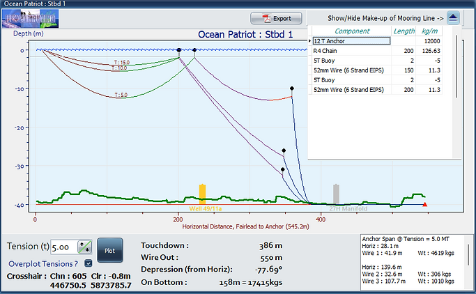
Mooring & Catenary Tool for Offshore Mooring configuration
Anchoring Analysis & Planning Tool
The "Anchor Planner" application is the perfect solution for computing, plotting, and exporting catenary calculations for mooring systems. GIS compatible, multi-buoy (10 max per line), dynamic linking allowing change of Tanker/Rig/FPSO position, auto line updating.
Import XYZ bathymetry data to ensure seabed clearance, the application provides accurate and detailed seabed profiles. Users can define obstructions as hazards and overlay different wire tensions, computing catenary plots to ensure safe clearance of seabed infrastructure..
The "Vessel Designer" feature allows users to create accurate vessel shapes with offset points for CRP and fairleads, mooring lines can be assigned to a fairlead, when the vessel position is moved e.g. from standoff to final location, all mooring lines are re-computed and catenaries plotted.
Configuration
-
Multiple projects and vessels can be configured.
-
Vessel shapes can be defined in detail.
-
Coordinate systems use EPSG codes for CRS.
-
A database of mooring line components e.g. chain, wire, anchors & buoys can be built and re-used.
-
Up to 12 mooring lines for a vessel.
-
Up to 10 surface buoys can be configured per line.
-
Tensions can be overlaid for comparison.
-
Interactive mouse to correlate the plan view and the selected catenary plot.
-
PDF report produced for a particular configuration.
-
Anchor plan can be exported to .SHP files.


Compatibility
-
GIS background to import standard .SHP, .GRD etc formats.
-
Option to interface with GPS and Gyro for live catenary plots and seabed dynamic clearance.
-
Windows 10 upwards